Geolocate

Turkey topographic map

Click on the map to display elevation.

About this map

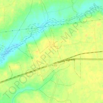
Name: Turkey topographic map, elevation, terrain.

Location: Turkey, Sampson County, North Carolina, United States (34.98829 -78.19159 35.00340 -78.17379)

Average elevation: 41 m

Minimum elevation: 26 m

Maximum elevation: 50 m

Other topographic maps

Click on a map to view its topography, its elevation and its terrain.

Elliott

United States > North Carolina > Sampson County

Average elevation: 35 m

Timothy

United States > North Carolina > Sampson County

Average elevation: 60 m

Gear up for your next adventure:

👟Waterproof Leg Gaiters - Keep mud and water out of your boots in boggy terrain
🗺️Scratch-off Peak Maps - Track your progress climbing Munros or Wainwrights
🧘Folding Sit Mats - Dry and warm seat for map-reading breaks on damp ground
🧰First Aid Kits - Essential safety kits for outdoor activities
🧊Personal Water Filters - Drink safely from mountain streams marked on your map

As an Amazon Associate, this site earns from qualifying purchases at no extra cost to you.