
Easton topographic map
Interactive map
Click on the map to display elevation.
About this map
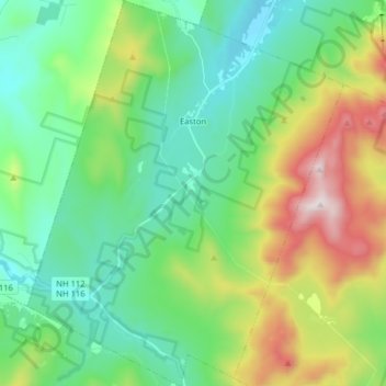
Name: Easton topographic map, elevation, terrain.
Location: Easton, Grafton County, New Hampshire, United States (44.06900 -71.85761 44.18327 -71.72703)
Average elevation: 586 m
Minimum elevation: 293 m
Maximum elevation: 1,316 m
Other topographic maps
Click on a map to view its topography, its elevation and its terrain.
Stinson Lake
United States > New Hampshire > Grafton County > Rumney > Stinson Lake
Average elevation: 460 m
Mount Kineo, East Peak
United States > New Hampshire > Grafton County > Ellsworth
Average elevation: 710 m
West Lebanon
United States > New Hampshire > Grafton County > Lebanon > West Lebanon
Average elevation: 165 m
North Littleton
United States > New Hampshire > Grafton County > Littleton > North Littleton
Average elevation: 333 m
LeBruns Mobile Home Park
United States > New Hampshire > Grafton County > Lebanon > LeBruns Mobile Home Park
Average elevation: 326 m