
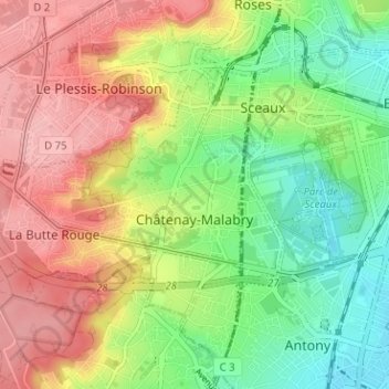
Châtenay-Malabry topographic map
Interactive map
Click on the map to display elevation.
About this map
Name: Châtenay-Malabry topographic map, elevation, terrain.
Average elevation: 111 m
Minimum elevation: 50 m
Maximum elevation: 179 m
Other topographic maps
Click on a map to view its topography, its elevation and its terrain.
Bagneux
Frankreich > Île-de-France > Hauts-de-Seine
Bagneux, Antony, Hauts-de-Seine, Île-de-France, Metropolitanes Frankreich, 92220, Frankreich
Average elevation: 91 m
Clamart
Frankreich > Île-de-France > Hauts-de-Seine
Clamart, Antony, Hauts-de-Seine, Île-de-France, Metropolitanes Frankreich, 92140, Frankreich
Average elevation: 126 m
Nanterre
Frankreich > Île-de-France > Hauts-de-Seine
Nanterre, Arrondissement de Nanterre, Hauts-de-Seine, Île-de-France, Metropolitanes Frankreich, 92000, Frankreich
Average elevation: 45 m
Suresnes
Frankreich > Île-de-France > Hauts-de-Seine
Suresnes, Arrondissement de Nanterre, Hauts-de-Seine, Île-de-France, Metropolitanes Frankreich, 92150, Frankreich
Average elevation: 62 m