Geolocate

Catbrook topographic map

Click on the map to display elevation.

About this map

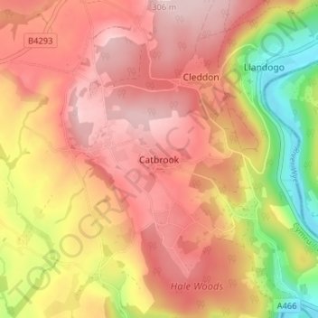
Name: Catbrook topographic map, elevation, terrain.

Location: Catbrook, Monmouthshire, Wales, NP16 6UG, United Kingdom (51.70202 -2.72889 51.74202 -2.68889)

Average elevation: 177 m

Minimum elevation: 4 m

Maximum elevation: 283 m

Monmouthshire trails, hiking, mountain biking, running and outdoor activities

Other topographic maps

Click on a map to view its topography, its elevation and its terrain.

Wye Valley

United Kingdom > Wales > Monmouthshire

Average elevation: 167 m

Penallt

United Kingdom > Wales > Monmouthshire

Average elevation: 174 m

Crucorney

United Kingdom > Wales > Monmouthshire

Average elevation: 297 m

Blorenge

United Kingdom > Wales > Monmouthshire > Govilon

Average elevation: 394 m

River Monnow

United Kingdom > Wales > Monmouthshire

Average elevation: 172 m

Llanbadoc

United Kingdom > Wales > Monmouthshire

Average elevation: 78 m

River Monnow

United Kingdom > Wales > Monmouthshire

Average elevation: 172 m

Raglan Castle

United Kingdom > Wales > Monmouthshire > Raglan

Average elevation: 59 m

Gear up for your next adventure:

🧺Microfibre Travel Towels - Fast-drying and compact towels for wild swimming and camping
🧘Folding Sit Mats - Dry and warm seat for map-reading breaks on damp ground
🥾Hiking Boot Waterproofing Wax - Maintain the lifespan of your leather trekking boots
🖼️Topographic Map Art - Decorative 3D-effect posters of famous UK peaks and regions
🛑Emergency Bivvy Bags - Heat-reflective survival bags for unexpected nights out

As an Amazon Associate, this site earns from qualifying purchases at no extra cost to you.