Geolocate

Parowan topographic map

Click on the map to display elevation.

About this map

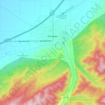
Name: Parowan topographic map, elevation, terrain.

Location: Parowan, Iron County, Utah, 84761, United States (37.79147 -112.88066 37.86791 -112.80414)

Average elevation: 2,002 m

Minimum elevation: 1,756 m

Maximum elevation: 2,536 m

Other topographic maps

Click on a map to view its topography, its elevation and its terrain.

Cedar Mountain

United States > Utah > Iron County

Average elevation: 2,512 m

North View

United States > Utah > Iron County

Average elevation: 3,072 m

Mammoth Summit

United States > Utah > Iron County

Average elevation: 3,150 m

Beryl

United States > Utah > Iron County

Average elevation: 1,574 m

Cedar Breaks

United States > Utah > Iron County

Average elevation: 2,843 m

Markagunt Plateau

United States > Utah > Iron County

Average elevation: 2,792 m

Cedar Breaks

United States > Utah > Iron County

Average elevation: 2,843 m

Gear up for your next adventure:

🔋Solar Power Banks - Keep your GPS and phone charged during multi-day expeditions
🧴Sport Sunscreen Sticks - High-protection sunblock that won't run into your eyes on the trail
🍲Portable Camping Stoves - Fast-boiling stoves for hot meals on remote topographic survey trips
📱Phone Mounts for Hiking - Secure mounts to carry your phone on trails
🧼Biodegradable Soap - Leave-no-trace hygiene for multi-day mountain treks

As an Amazon Associate, this site earns from qualifying purchases at no extra cost to you.