
Make a donation
Gear up for your next adventure:
As an Amazon Associate, this site earns from qualifying purchases at no extra cost to you.
Puckington topographic map
Click on the map to display elevation.
Make a donation
Gear up for your next adventure:
As an Amazon Associate, this site earns from qualifying purchases at no extra cost to you.
About this map
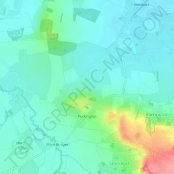
Name: Puckington topographic map, elevation, terrain.
Location: Puckington, South Somerset, Somerset, England, United Kingdom (50.95631 -2.91686 50.97127 -2.87906)
Average elevation: 27 m
Minimum elevation: 7 m
Maximum elevation: 97 m
Somerset trails, hiking, mountain biking, running and outdoor activities
Make a donation
Gear up for your next adventure:
As an Amazon Associate, this site earns from qualifying purchases at no extra cost to you.
Other topographic maps
Click on a map to view its topography, its elevation and its terrain.
Wales
United Kingdom > England > Somerset > South Somerset > West Camel > Wales
Average elevation: 34 m
Small Brook
United Kingdom > England > Somerset > South Somerset > Haselbury Plucknett
Average elevation: 48 m
Hill End
United Kingdom > England > Somerset > South Somerset > Hardington Mandeville > Hill End
Average elevation: 62 m
Watergore
United Kingdom > England > Somerset > South Somerset > Over Stratton
Average elevation: 42 m
Make a donation
Gear up for your next adventure:
As an Amazon Associate, this site earns from qualifying purchases at no extra cost to you.
Hurcott
United Kingdom > England > Somerset > South Somerset > Littleton > Hurcott
Average elevation: 46 m
Woodhouse
United Kingdom > England > Somerset > South Somerset > Rimpton > Woodhouse
Average elevation: 74 m
Make a donation
Gear up for your next adventure:
As an Amazon Associate, this site earns from qualifying purchases at no extra cost to you.
Kingsbury Regis
United Kingdom > England > Somerset > South Somerset > Milborne Port
Average elevation: 97 m