
Make a donation
Gear up for your next adventure:
As an Amazon Associate, this site earns from qualifying purchases at no extra cost to you.
Union Lake topographic map
Click on the map to display elevation.
Make a donation
Gear up for your next adventure:
As an Amazon Associate, this site earns from qualifying purchases at no extra cost to you.
About this map
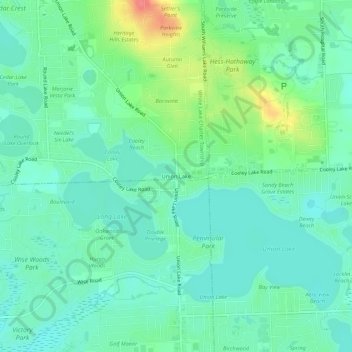
Name: Union Lake topographic map, elevation, terrain.
Average elevation: 290 m
Minimum elevation: 272 m
Maximum elevation: 338 m
Make a donation
Gear up for your next adventure:
As an Amazon Associate, this site earns from qualifying purchases at no extra cost to you.
Other topographic maps
Click on a map to view its topography, its elevation and its terrain.
White Lake
United States > Michigan > Oakland County > White Lake Charter Township
Average elevation: 314 m
Pontiac Lake State Recreation Area
United States > Michigan > Oakland County > White Lake Charter Township
Average elevation: 305 m
White Lake
United States > Michigan > Oakland County > White Lake Charter Township
Average elevation: 314 m
Cranberry Lake
United States > Michigan > Oakland County > White Lake Charter Township
Average elevation: 295 m
Make a donation
Gear up for your next adventure:
As an Amazon Associate, this site earns from qualifying purchases at no extra cost to you.