
Laredo topographic map
Interactive map
Click on the map to display elevation.
About this map
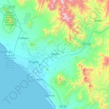
Name: Laredo topographic map, elevation, terrain.
Location: Laredo, Trujillo, La Libertad, Perú (-8.20955 -79.00091 -7.96745 -78.63763)
Average elevation: 423 m
Minimum elevation: -1 m
Maximum elevation: 2,159 m
Other topographic maps
Click on a map to view its topography, its elevation and its terrain.
Romeria
Perú > La Libertad > Longotea
Romeria, Longotea, Bolívar, La Libertad, Perú
Average elevation: 3,022 m
Chocope
Perú > La Libertad > Chocope
Chocope, Provincia de Ascope, La Libertad, Perú
Average elevation: 113 m
Huanchaco
Perú > La Libertad > Huanchaco
Huanchaco, Provincia de Trujillo, La Libertad, 045, Perú
Average elevation: 174 m