
Amorbach topographic map
Interactive map
Click on the map to display elevation.
About this map
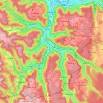
Name: Amorbach topographic map, elevation, terrain.
Location: Amorbach, Landkreis Miltenberg, Bayern, 63916, Deutschland (49.57875 9.08796 49.69697 9.30649)
Average elevation: 353 m
Minimum elevation: 123 m
Maximum elevation: 538 m
Amorbach liegt im Odenwald in waldreicher Umgebung in dem in Süd-Nord-Richtung zum Main führenden Mudtal. Der topographisch höchste Punkt der Stadt befindet sich mit 506 m ü. NHN am Gipfel der Boxbrunner Höhe, der niedrigste liegt an der Mud auf 150 m ü. NHN.
Other topographic maps
Click on a map to view its topography, its elevation and its terrain.
Bürgstadt
Deutschland > Bayern > Landkreis Miltenberg
Bürgstadt, Verwaltungsgemeinschaft Erftal, Landkreis Miltenberg, Bayern, 63927, Deutschland
Average elevation: 237 m
Elsenfeld
Deutschland > Bayern > Landkreis Miltenberg
Elsenfeld, Landkreis Miltenberg, Bayern, 63820, Deutschland
Average elevation: 191 m