
Make a donation
Gear up for your next adventure:
As an Amazon Associate, this site earns from qualifying purchases at no extra cost to you.
Abraham Lake topographic map
Click on the map to display elevation.
Make a donation
Gear up for your next adventure:
As an Amazon Associate, this site earns from qualifying purchases at no extra cost to you.
Abraham Lake
The Government of Alberta sponsored a contest to name the lake in February 1972, during the final stages of construction of the Bighorn Dam. Students across the province were asked to submit names taking into consideration "historical significance, prominent persons, geography and topography, and the value of the lake." It was eventually named after Silas Abraham (c. 1870–1964), of the Stoney Nakoda First Nation and originally from Morley, Alberta. He was a farmer and hunter who lived in the Kootenay Plains and later on the Big Horn 144A reserve.
Make a donation
Gear up for your next adventure:
As an Amazon Associate, this site earns from qualifying purchases at no extra cost to you.
About this map
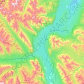
Name: Abraham Lake topographic map, elevation, terrain.
Location: Abraham Lake, Census Division No. 9, Alberta, Canada (52.07360 -116.48898 52.33277 -116.32587)
Average elevation: 1,886 m
Minimum elevation: 1,222 m
Maximum elevation: 3,095 m
Make a donation
Gear up for your next adventure:
As an Amazon Associate, this site earns from qualifying purchases at no extra cost to you.
Other topographic maps
Click on a map to view its topography, its elevation and its terrain.
Moutain Vew Park
Canada > Alberta > Census Division No. 9 > Rocky Mountain House
Average elevation: 978 m