Geolocate

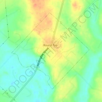
Round Top topographic map

Click on the map to display elevation.

Round Top

Round Top is located in northeastern Fayette County. It sits on a hill between Cummins Creek to the southwest and Rocky Creek to the east, tributaries of the Colorado River. The elevation in the center of Round Top is 439 feet (134 m) above sea level. Texas State Highway 237 passes through the center of town, leading northeast 22 miles (35 km) to Brenham and southwest 16 miles (26 km) to La Grange, the Fayette County seat.

Wikipedia (CC-BY-SA 3.0)

About this map

Name: Round Top topographic map, elevation, terrain.

Location: Round Top, Fayette County, Texas, United States (30.05354 -96.70801 30.07380 -96.68419)

Average elevation: 120 m

Minimum elevation: 100 m

Maximum elevation: 143 m

Other topographic maps

Click on a map to view its topography, its elevation and its terrain.
Cedar Creek Dam

United States > Texas > Fayette County > Tamberg

Average elevation: 113 m

Ledbetter

United States > Texas > Fayette County

Average elevation: 128 m

Warda

United States > Texas > Fayette County

Average elevation: 106 m

Freyburg

United States > Texas > Fayette County

Average elevation: 114 m

Muldoon

United States > Texas > Fayette County

Average elevation: 104 m

Gear up for your next adventure:

👕Merino Base Layers - Natural temperature regulation for cold weather hiking and camping
🔋Lithium AA Batteries - Long-lasting power that performs well in cold mountain weather
🧤Hiking Gloves - Warm and durable gloves for cold-weather walks
🛰️Handheld GPS Devices - Reliable GPS units for hiking and outdoor navigation
🔦Outdoor Torches - Reliable torches for night navigation

As an Amazon Associate, this site earns from qualifying purchases at no extra cost to you.