
Village of Andover topographic map
Interactive map
Click on the map to display elevation.
About this map
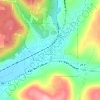
Name: Village of Andover topographic map, elevation, terrain.
Average elevation: 561 m
Minimum elevation: 492 m
Maximum elevation: 671 m
Other topographic maps
Click on a map to view its topography, its elevation and its terrain.
Town of Birdsall
United States > New York > Allegany County
Town of Birdsall, Allegany County, New York, United States
Average elevation: 581 m
Village of Alfred
United States > New York > Allegany County
Village of Alfred, Town of Alfred, Allegany County, New York, 14802, United States
Average elevation: 597 m
Town of Wellsville
United States > New York > Allegany County
Town of Wellsville, Allegany County, New York, 14895, United States
Average elevation: 564 m
Town of Rushford
United States > New York > Allegany County
Town of Rushford, Allegany County, New York, United States
Average elevation: 528 m
Swain
United States > New York > Allegany County
Swain, Town of Grove, Allegany County, New York, 14884, United States
Average elevation: 503 m
Almond
United States > New York > Allegany County > Almond
Almond, Allegany County, New York, United States
Average elevation: 470 m
Birdsall
United States > New York > Allegany County
Birdsall, Town of Birdsall, Allegany County, New York, United States
Average elevation: 582 m