Geolocate

Singa topographic map

Click on the map to display elevation.

Singa

Singa (Arabic: سنجة) is a town located in the Sennar State of Sudan at an elevation of 439 meters (1,440 feet) above sea level. The town is situated on the west bank of the Blue Nile at a distance of 360 kilometers (220 miles) to the southeast of the capital, Khartoum, and 60 kilometers from Sennar city. Its population was recorded to be 259,000 in 2002.

Wikipedia (CC-BY-SA 3.0)

About this map

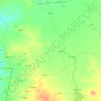
Name: Singa topographic map, elevation, terrain.

Location: Singa, Sennar State, Sudan (11.67454 33.08204 13.36110 34.34233)

Average elevation: 462 m

Minimum elevation: 400 m

Maximum elevation: 785 m

Other topographic maps

Click on a map to view its topography, its elevation and its terrain.

Dinder National Park

Sudan > Sennar State

Average elevation: 548 m

Banasu

Sudan > Sennar State > Ad Dinder

Average elevation: 436 m

As Siraj

Sudan > Sennar State > Sennar

Average elevation: 430 m

Jalqani

Sudan > Sennar State > Ad Dinder

Average elevation: 450 m

Gear up for your next adventure:

📚UK Hiking Guidebooks - Detailed route descriptions for the Lake District, Peaks, and Highlands
🧊Insulated Flasks - Keeps drinks hot or cold during hikes
🔋Lithium AA Batteries - Long-lasting power that performs well in cold mountain weather
👖Hiking Trousers - Durable trousers designed for rough terrain
Insulated Travel Mugs - Keep drinks hot while surveying the landscape from a summit

As an Amazon Associate, this site earns from qualifying purchases at no extra cost to you.