
Lydford-on-Fosse topographic map
Interactive map
Click on the map to display elevation.
About this map
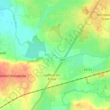
Name: Lydford-on-Fosse topographic map, elevation, terrain.
Location: Lydford-on-Fosse, Mendip, Somerset, England, United Kingdom (51.06329 -2.64252 51.10535 -2.58604)
Average elevation: 31 m
Minimum elevation: 10 m
Maximum elevation: 58 m
Other topographic maps
Click on a map to view its topography, its elevation and its terrain.
West Pennard
United Kingdom > England > Somerset > Mendip > West Pennard
West Pennard, Mendip, Somerset, South West England, England, United Kingdom
Average elevation: 25 m
Spring Gardens
United Kingdom > England > Somerset > Mendip > Spring Gardens
Spring Gardens, Mendip, Somerset, South West England, England, BA11 2PA, United Kingdom
Average elevation: 88 m
Charterhouse
United Kingdom > England > Somerset > Mendip > Charterhouse
Charterhouse, Mendip, Somerset, South West England, England, BS40 7XS, United Kingdom
Average elevation: 255 m
East Horrington
United Kingdom > England > Somerset > Mendip > East Horrington
East Horrington, Mendip, Somerset, South West England, England, BA5 3DT, United Kingdom
Average elevation: 173 m