Geolocate

Banlic topographic map

Click on the map to display elevation.

About this map

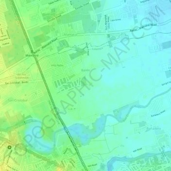
Name: Banlic topographic map, elevation, terrain.

Location: Banlic, Calamba, Laguna, Calabarzon, 4027, Philippines (14.21858 121.14622 14.23534 121.17149)

Average elevation: 14 m

Minimum elevation: 5 m

Maximum elevation: 27 m

Other topographic maps

Click on a map to view its topography, its elevation and its terrain.

Bucal

Philippines > Laguna > Calamba

Average elevation: 22 m

88 Spa & Resort

Philippines > Laguna > Calamba

Average elevation: 83 m

ASN Ph2 Park

Philippines > Laguna > Calamba

Average elevation: 133 m

Bucal Reservoir

Philippines > Laguna > Calamba

Average elevation: 42 m

Calamba Town Plaza

Philippines > Laguna > Calamba

Average elevation: 11 m

Gear up for your next adventure:

📻Hand-Crank Emergency Radios - Stay updated on weather warnings in remote areas
🪓Outdoor Multitools - Versatile tools for hiking and camping
📷Camera Straps - Secure straps for carrying cameras while walking
🧢Hiking Hats - Sun and weather protection for outdoor walks
👟Women's Trail Running Shoes - Agile footwear for fell running and technical trails

As an Amazon Associate, this site earns from qualifying purchases at no extra cost to you.