
Summer Lake topographic map
Interactive map
Click on the map to display elevation.
About this map
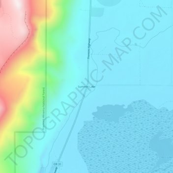
Name: Summer Lake topographic map, elevation, terrain.
Location: Summer Lake, Lake County, Oregon, 97640, United States (42.95271 -120.79813 42.99271 -120.75813)
Average elevation: 1,406 m
Minimum elevation: 1,263 m
Maximum elevation: 2,033 m
Other topographic maps
Click on a map to view its topography, its elevation and its terrain.
Lakeview
United States > Oregon > Lake County
Lakeview is a town in Lake County, Oregon, United States. The population was 2,418 at the 2020 census. It is the county seat of Lake County. The city bills itself as the "Tallest Town in Oregon" because of its elevation, 4,757 feet (1,450 m) above sea level. Lakeview is situated in the Goose Lake Valley at the…
Average elevation: 1,562 m