Geolocate

Val Sangone topographic map

Click on the map to display elevation.

About this map
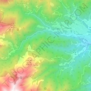
Name: Val Sangone topographic map, elevation, terrain.

Location: Val Sangone, Coazze, Torino, Piemonte, Italia (45.02882 7.23225 45.05041 7.32414)

Average elevation: 1,054 m

Minimum elevation: 566 m

Maximum elevation: 1,998 m

Other topographic maps

Click on a map to view its topography, its elevation and its terrain.

Ruadamonte

Italia > Piemonte > Torino > Coazze

Average elevation: 855 m

Forno di Coazze

Italia > Piemonte > Torino > Coazze

Average elevation: 1,247 m

Dirotto-Sangonetto

Italia > Piemonte > Torino > Coazze

Average elevation: 922 m

Cervelli

Italia > Piemonte > Torino > Coazze

Average elevation: 993 m

Fontana del Lago

Italia > Piemonte > Torino > Coazze

Average elevation: 2,273 m

Merlo

Italia > Piemonte > Torino > Coazze

Average elevation: 1,201 m

Borgata Trucetto

Italia > Piemonte > Torino > Coazze > Ruadamonte

Average elevation: 773 m

Marini

Italia > Piemonte > Torino > Coazze

Average elevation: 953 m

Clotti

Italia > Piemonte > Torino > Coazze

Average elevation: 998 m

Forno di Coazze

Italia > Piemonte > Torino > Coazze

Average elevation: 1,247 m

Gear up for your next adventure:

🔋Power Banks - Portable chargers for long outdoor trips
👟Women's Trail Running Shoes - Agile footwear for fell running and technical trails
🛌Sleeping Bags - Warm and packable sleeping bags for outdoor nights
❄️Walking Crampons - Added traction for icy slopes and winter peak bagging
💧Hydration Reservoirs - Convenient water bladders for hands-free drinking on the move

As an Amazon Associate, this site earns from qualifying purchases at no extra cost to you.