
Thank you for supporting this site ❤️
Make a donation
Make a donation
Gear up for your next adventure:
As an Amazon Associate, this site earns from qualifying purchases at no extra cost to you.
Roldanillo topographic map
Click on the map to display elevation.
Thank you for supporting this site ❤️
Make a donation
Make a donation
Gear up for your next adventure:
As an Amazon Associate, this site earns from qualifying purchases at no extra cost to you.
About this map
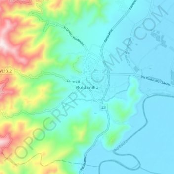
Name: Roldanillo topographic map, elevation, terrain.
Location: Roldanillo, Norte, Valle del Cauca, 761550, Colombia (4.36912 -76.19437 4.44912 -76.11437)
Average elevation: 1,070 m
Minimum elevation: 907 m
Maximum elevation: 1,670 m
Thank you for supporting this site ❤️
Make a donation
Make a donation
Gear up for your next adventure:
As an Amazon Associate, this site earns from qualifying purchases at no extra cost to you.