
Novocheboksarsk topographic map
Interactive map
Click on the map to display elevation.
About this map
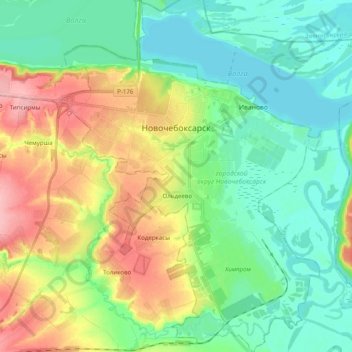
Name: Novocheboksarsk topographic map, elevation, terrain.
Location: Novocheboksarsk, Chuvashia, Volga Federal District, Russia (56.04354 47.42148 56.15381 47.56883)
Average elevation: 87 m
Minimum elevation: 48 m
Maximum elevation: 164 m
Other topographic maps
Click on a map to view its topography, its elevation and its terrain.
Тансарино
Russia > Chuvashia > Urmarsky District > Тансарино
Тансарино, Кульгешское сельское поселение, Urmarsky District, Chuvashia, Volga Federal District, Russia
Average elevation: 161 m
Novocheboksarsk
Russia > Chuvashia > Novocheboksarsk
Novocheboksarsk, Chuvashia, Volga Federal District, Russia
Average elevation: 87 m