
Bandar Lengeh topographic map
Interactive map
Click on the map to display elevation.
About this map
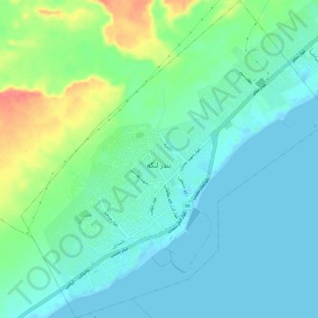
Name: Bandar Lengeh topographic map, elevation, terrain.
Average elevation: 18 m
Minimum elevation: -5 m
Maximum elevation: 72 m
Other topographic maps
Click on a map to view its topography, its elevation and its terrain.
Shidvar Island
Iran > Hormozgan Province > Bandar Lengeh County > دهستان لاوان
Shidvar Island, دهستان لاوان, بخش کیش, Bandar Lengeh County, Hormozgan Province, Iran
Average elevation: 0 m
Kish
Iran > Hormozgan Province > Bandar Lengeh County > جزیره کیش
Kish, دهستان کیش, بخش کیش, Bandar Lengeh County, Hormozgan Province, Iran
Average elevation: 6 m