
Haeju topographic map
Interactive map
Click on the map to display elevation.
About this map
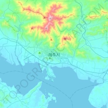
Name: Haeju topographic map, elevation, terrain.
Location: Haeju, South Hwanghae, North Korea (37.96190 125.60470 38.12001 125.84730)
Average elevation: 110 m
Minimum elevation: -1 m
Maximum elevation: 908 m
Haeju City is located on the westernmost edge of the Korean Peninsula, 60 km north of the Military Demarcation Line and 100 km south of Pyongyang. The city, being not very mountainous, is composed mostly of plains. All the mountains located within the city are under 1,000 m in elevation.