Geolocate

Winston topographic map

Click on the map to display elevation.

About this map

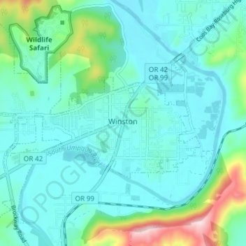
Name: Winston topographic map, elevation, terrain.

Location: Winston, Douglas County, Oregon, 97496, United States (43.10343 -123.45509 43.13990 -123.39360)

Average elevation: 196 m

Minimum elevation: 141 m

Maximum elevation: 442 m

Gear up for your next adventure:

🧣Fleece Neck Warmers - Extra insulation for winter topographic surveys
🎒Hiking Daypacks (20L) - Compact backpacks for day trips and technical mountain ascents
🎒Hiking Child Carriers - Explore the outdoors with the whole family safely
🧭GPS Trackers - Tracking devices for safety and navigation
🧊Personal Water Filters - Drink safely from mountain streams marked on your map

As an Amazon Associate, this site earns from qualifying purchases at no extra cost to you.