
Make a donation
Gear up for your next adventure:
As an Amazon Associate, this site earns from qualifying purchases at no extra cost to you.
El Menia topographic map
Click on the map to display elevation.
Make a donation
Gear up for your next adventure:
As an Amazon Associate, this site earns from qualifying purchases at no extra cost to you.
El Menia
El Menia is located almost at the center of Algeria, lying at the eastern border of the Grand Erg Occidental at an elevation of 380 metres (1,250 ft). The town is a gateway to the Sahara in the south, and has an estimated 180,000 palm trees within the oasis area. The oasis itself lies beneath an escarpment rising up to 200 metres (660 ft) above. Some of the largest continuous areas of Saharan sand dunes begin just a few kilometres to the west of the oasis.
Make a donation
Gear up for your next adventure:
As an Amazon Associate, this site earns from qualifying purchases at no extra cost to you.
About this map
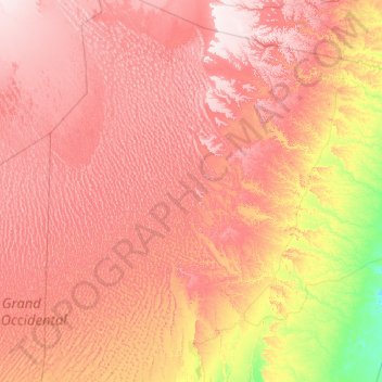
Name: El Menia topographic map, elevation, terrain.
Location: El Menia, El Menia District, El Menia, Algeria (30.54009 2.02364 32.19268 4.25636)
Average elevation: 487 m
Minimum elevation: 278 m
Maximum elevation: 695 m
Make a donation
Gear up for your next adventure:
As an Amazon Associate, this site earns from qualifying purchases at no extra cost to you.