Geolocate

Ponteix topographic map

Click on the map to display elevation.

About this map

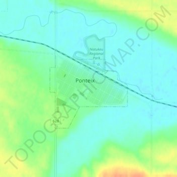
Name: Ponteix topographic map, elevation, terrain.

Location: Ponteix, Saskatchewan, S0N 1Z0, Canada (49.73870 -107.49640 49.75077 -107.47809)

Average elevation: 752 m

Minimum elevation: 740 m

Maximum elevation: 776 m

Other topographic maps

Click on a map to view its topography, its elevation and its terrain.

Smoothstone River

Canada > Saskatchewan

Average elevation: 545 m

Ravenscrag

Canada > Saskatchewan > White Valley No. 49

Average elevation: 984 m

Laflèche

Canada > Saskatchewan > Laflèche

Average elevation: 740 m

Cypress Hills

Canada > Saskatchewan

Average elevation: 1,183 m

Leader

Canada > Saskatchewan

Average elevation: 674 m

St-Denis

Canada > Saskatchewan > Grant No. 372

Average elevation: 553 m

Gear up for your next adventure:

🧥Waterproof Hiking Jackets - Rain protection for walking in all weather conditions
🎒Multi-day Trekking Packs - Large capacity backpacks for wild camping and long-distance trails
🕶️Glacier Goggles - Maximum protection for high-altitude snow topography
🎒Replacement Sternum Straps - Repair parts for hiking rucksacks
🧼Biodegradable Soap - Leave-no-trace hygiene for multi-day mountain treks

As an Amazon Associate, this site earns from qualifying purchases at no extra cost to you.