
Make a donation
Gear up for your next adventure:
As an Amazon Associate, this site earns from qualifying purchases at no extra cost to you.
Tullahoma topographic map
Click on the map to display elevation.
Make a donation
Gear up for your next adventure:
As an Amazon Associate, this site earns from qualifying purchases at no extra cost to you.
Tullahoma
Tullahoma is located in the southwest corner of Coffee County at 35°22′7″N 86°12′48″W / 35.36861°N 86.21333°W / 35.36861; -86.21333 (35.368511, -86.213258), and extends south into Franklin County. It is situated at the edge of the Highland Rim, with flatter topography than in the surrounding area. The region was known as "the Barrens" to the first settlers.
Make a donation
Gear up for your next adventure:
As an Amazon Associate, this site earns from qualifying purchases at no extra cost to you.
About this map
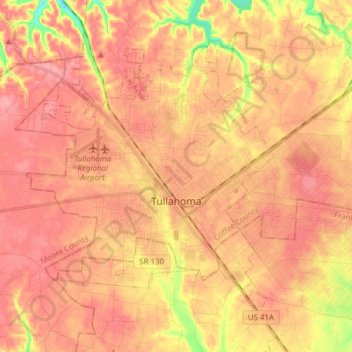
Name: Tullahoma topographic map, elevation, terrain.
Average elevation: 323 m
Minimum elevation: 263 m
Maximum elevation: 349 m
Make a donation
Gear up for your next adventure:
As an Amazon Associate, this site earns from qualifying purchases at no extra cost to you.
Other topographic maps
Click on a map to view its topography, its elevation and its terrain.
Make a donation
Gear up for your next adventure:
As an Amazon Associate, this site earns from qualifying purchases at no extra cost to you.