
Make a donation
Gear up for your next adventure:
As an Amazon Associate, this site earns from qualifying purchases at no extra cost to you.
Beechgrove topographic map
Click on the map to display elevation.
Make a donation
Gear up for your next adventure:
As an Amazon Associate, this site earns from qualifying purchases at no extra cost to you.
About this map
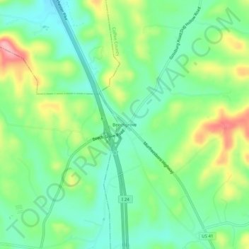
Name: Beechgrove topographic map, elevation, terrain.
Average elevation: 289 m
Minimum elevation: 243 m
Maximum elevation: 374 m
Make a donation
Gear up for your next adventure:
As an Amazon Associate, this site earns from qualifying purchases at no extra cost to you.
Other topographic maps
Click on a map to view its topography, its elevation and its terrain.
Tullahoma
United States > Tennessee > Coffee County
Tullahoma is located in the southwest corner of Coffee County at 35°22′7″N 86°12′48″W / 35.36861°N 86.21333°W / 35.36861; -86.21333 (35.368511, -86.213258), and extends south into Franklin County. It is situated at the edge of the Highland Rim, with flatter topography than in the…
Average elevation: 323 m
Make a donation
Gear up for your next adventure:
As an Amazon Associate, this site earns from qualifying purchases at no extra cost to you.