
Thank you for supporting this site ❤️
Make a donation
Make a donation
Gear up for your next adventure:
As an Amazon Associate, this site earns from qualifying purchases at no extra cost to you.
Yoder topographic map
Click on the map to display elevation.
Thank you for supporting this site ❤️
Make a donation
Make a donation
Gear up for your next adventure:
As an Amazon Associate, this site earns from qualifying purchases at no extra cost to you.
About this map
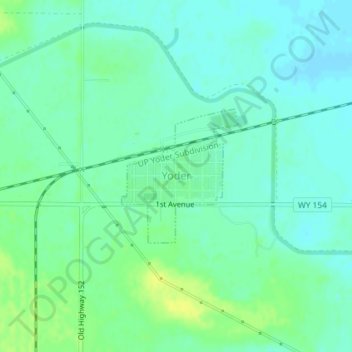
Name: Yoder topographic map, elevation, terrain.
Location: Yoder, Goshen County, Wyoming, United States (41.91172 -104.30145 41.92201 -104.28943)
Average elevation: 1,294 m
Minimum elevation: 1,287 m
Maximum elevation: 1,305 m
Thank you for supporting this site ❤️
Make a donation
Make a donation
Gear up for your next adventure:
As an Amazon Associate, this site earns from qualifying purchases at no extra cost to you.
Other topographic maps
Click on a map to view its topography, its elevation and its terrain.
Goshen County Fair Grounds
United States > Wyoming > Goshen County > Torrington
Average elevation: 1,258 m