
Make a donation
Gear up for your next adventure:
As an Amazon Associate, this site earns from qualifying purchases at no extra cost to you.
Hurley topographic map
Click on the map to display elevation.
Make a donation
Gear up for your next adventure:
As an Amazon Associate, this site earns from qualifying purchases at no extra cost to you.
About this map
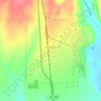
Name: Hurley topographic map, elevation, terrain.
Location: Hurley, Grant County, New Mexico, United States (32.68967 -108.13981 32.70713 -108.12378)
Average elevation: 1,734 m
Minimum elevation: 1,694 m
Maximum elevation: 1,778 m
Make a donation
Gear up for your next adventure:
As an Amazon Associate, this site earns from qualifying purchases at no extra cost to you.
Other topographic maps
Click on a map to view its topography, its elevation and its terrain.
Make a donation
Gear up for your next adventure:
As an Amazon Associate, this site earns from qualifying purchases at no extra cost to you.
Basin and Range Country Historical Marker
United States > New Mexico > Grant County
Average elevation: 1,393 m