
Millersville topographic map
Interactive map
Click on the map to display elevation.
About this map
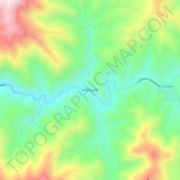
Name: Millersville topographic map, elevation, terrain.
Location: Millersville, Kern County, California, United States (35.28385 -118.47786 35.32385 -118.43786)
Average elevation: 964 m
Minimum elevation: 721 m
Maximum elevation: 1,358 m
Other topographic maps
Click on a map to view its topography, its elevation and its terrain.
Bakersfield
United States > California > Kern County
Bakersfield, Kern County, California, United States
Average elevation: 157 m
Bear Valley Springs
United States > California > Kern County
Bear Valley Springs, Kern County, California, United States
Average elevation: 1,204 m
Frazier Park
United States > California > Kern County
Frazier Park, Kern County, California, United States
Average elevation: 1,533 m
Ridgecrest
United States > California > Kern County
Ridgecrest, Kern County, California, 93555, United States
Average elevation: 739 m
Weldon
United States > California > Kern County
Weldon, Kern County, California, 93283, United States
Average elevation: 1,030 m
Fellows
United States > California > Kern County
Fellows, Kern County, California, United States
Average elevation: 420 m
Kernville
United States > California > Kern County
Kernville, Kern County, California, 93238, United States
Average elevation: 1,135 m
East Bakersfield
United States > California > Kern County
East Bakersfield, Kern County, California, 93305, United States
Average elevation: 158 m
Potomac County Park
United States > California > Kern County
Potomac County Park, Kern County, California, United States
Average elevation: 130 m
Hillcrest Point
United States > California > Kern County
Hillcrest Point, Kern County, California, United States
Average elevation: 411 m
Rosedale
United States > California > Kern County
Rosedale, Kern County, California, United States
Average elevation: 113 m
Shafter
United States > California > Kern County
Shafter, Kern County, California, 93253, United States
Average elevation: 108 m
South Taft
United States > California > Kern County > Taft > South Taft
South Taft, Taft, Kern County, California, United States
Average elevation: 343 m
Bakersfield
United States > California > Kern County > Bakersfield
Bakersfield, Kern County, California, 93301, United States
Average elevation: 161 m
Ford City
United States > California > Kern County > Taft
Ford City, Taft, Kern County, California, United States
Average elevation: 264 m
Shirley Meadows
United States > California > Kern County
Shirley Meadows, Kern County, California, United States
Average elevation: 1,848 m
Buttonwillow
United States > California > Kern County
Buttonwillow, Kern County, California, 93206, United States
Average elevation: 87 m
Blue Moon Ranch
United States > California > Kern County
Blue Moon Ranch, Kern County, California, United States
Average elevation: 77 m
Lost Hills
United States > California > Kern County
Lost Hills, Kern County, California, 93249, United States
Average elevation: 82 m
Lokern
United States > California > Kern County
Lokern, Kern County, California, United States
Average elevation: 89 m
Brown
United States > California > Kern County
Brown, Kern County, California, United States
Average elevation: 732 m
Bodfish
United States > California > Kern County
Bodfish, Kern County, California, 93205, United States
Average elevation: 897 m
Lebec
United States > California > Kern County
Lebec, Kern County, California, 93243, United States
Average elevation: 1,162 m
Quailwood
United States > California > Kern County > Bakersfield
Quailwood, Bakersfield, Kern County, CAL Fire Southern Region, California, 93309, United States
Average elevation: 119 m
Rancho Seco
United States > California > Kern County
Rancho Seco, Kern County, California, United States
Average elevation: 623 m
Stallion Springs
United States > California > Kern County > Stallion Springs
Stallion Springs, Kern County, California, United States
Average elevation: 1,197 m
Brite Lake Recreational Park
United States > California > Kern County
Brite Lake Recreational Park, Kern County, California, United States
Average elevation: 1,354 m
Oildale
United States > California > Kern County
Oildale, Kern County, California, United States
Average elevation: 164 m
California City
United States > California > Kern County
California City, Kern County, California, United States
Average elevation: 845 m
Shafter
United States > California > Kern County
Shafter, City of Shafter, Kern County, CAL Fire Southern Region, California, United States
Average elevation: 120 m
Wofford Heights
United States > California > Kern County
Wofford Heights, Kern County, California, 93285, United States
Average elevation: 1,114 m
Rosedale
United States > California > Kern County
Rosedale, Kern County, CAL Fire Contract Counties, California, United States
Average elevation: 107 m
Greenfield
United States > California > Kern County
Greenfield, Kern County, California, United States
Average elevation: 106 m
Twin Oaks
United States > California > Kern County
Twin Oaks, Kern County, California, United States
Average elevation: 945 m
Keene
United States > California > Kern County
Keene, Kern County, California, 93531, United States
Average elevation: 892 m
Golden Hills
United States > California > Kern County
Golden Hills, Kern County, California, 93561, United States
Average elevation: 1,275 m
Delano
United States > California > Kern County
Delano, Kern County, California, 93215, United States
Average elevation: 99 m
Grapevine
United States > California > Kern County
Grapevine, Kern County, California, United States
Average elevation: 501 m
Inyokern
United States > California > Kern County
Inyokern, Kern County, California, United States
Average elevation: 753 m
Sand Canyon
United States > California > Kern County
Sand Canyon, Kern County, California, United States
Average elevation: 936 m
Taft Heights
United States > California > Kern County > Taft > Taft Heights
Taft Heights, Taft, Kern County, California, United States
Average elevation: 368 m
Smith Corner
United States > California > Kern County
Smith Corner, Kern County, CAL Fire Southern Region, California, 93263, United States
Average elevation: 103 m
Pine Mountain Club
United States > California > Kern County
Pine Mountain Club, Kern County, California, 93222, United States
Average elevation: 1,867 m
City of Bakersfield
United States > California > Kern County
City of Bakersfield, Kern County, California, 93304, United States
Average elevation: 120 m
Taft
United States > California > Kern County
Taft, Kern County, California, 93268, United States
Average elevation: 370 m
Rosamond
United States > California > Kern County
Rosamond, Kern County, California, 93560, United States
Average elevation: 749 m
Old River
United States > California > Kern County
Old River, Kern County, California, United States
Average elevation: 103 m
Woodford
United States > California > Kern County
Woodford, El Rita, Kern County, California, United States
Average elevation: 899 m
Tehachapi
United States > California > Kern County
Tehachapi, Kern County, California, United States
Average elevation: 1,414 m
Baker
United States > California > Kern County > Boron
Baker, Boron, Kern County, California, United States
Average elevation: 765 m