
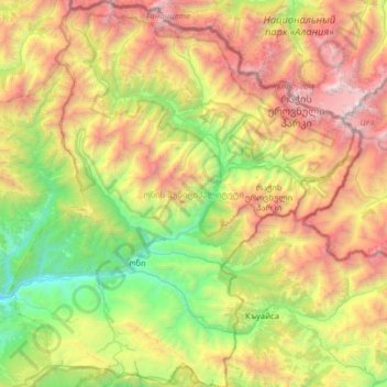
Oni, Georgia topographic map
Interactive map
Click on the map to display elevation.
About this map
Name: Oni, Georgia topographic map, elevation, terrain.
Location: Oni, Georgia, Racha-Lechkhumi and Lower Svaneti, Georgia (42.43570 43.23767 42.89935 43.79587)
Average elevation: 2,123 m
Minimum elevation: 621 m
Maximum elevation: 4,602 m
Other topographic maps
Click on a map to view its topography, its elevation and its terrain.