
Bordentown Township topographic map
Interactive map
Click on the map to display elevation.
About this map
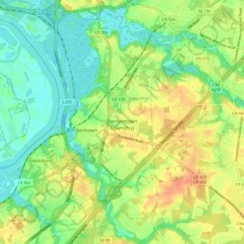
Name: Bordentown Township topographic map, elevation, terrain.
Average elevation: 18 m
Minimum elevation: -2 m
Maximum elevation: 40 m
Other topographic maps
Click on a map to view its topography, its elevation and its terrain.
Marlboro
United States > New Jersey > Burlington County > Evesham Township > Marlton
Average elevation: 26 m
Timbuctoo
United States > New Jersey > Burlington County > Westampton Township
Average elevation: 14 m
Jobstown
United States > New Jersey > Burlington County > Springfield Township
Average elevation: 22 m
Pine Lane
United States > New Jersey > Burlington County > Springfield Township
Average elevation: 25 m
Riverton
United States > New Jersey > Burlington County > Cinnaminson Township
Average elevation: 12 m
Fellowship
United States > New Jersey > Burlington County > Mount Laurel Township
Average elevation: 16 m
Hampton Gate
United States > New Jersey > Burlington County > Tabernacle Township
Average elevation: 24 m