
Make a donation
Gear up for your next adventure:
As an Amazon Associate, this site earns from qualifying purchases at no extra cost to you.
Mopane Dam topographic map
Click on the map to display elevation.
Make a donation
Gear up for your next adventure:
As an Amazon Associate, this site earns from qualifying purchases at no extra cost to you.
About this map
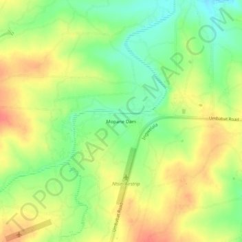
Name: Mopane Dam topographic map, elevation, terrain.
Average elevation: 337 m
Minimum elevation: 309 m
Maximum elevation: 364 m
Make a donation
Gear up for your next adventure:
As an Amazon Associate, this site earns from qualifying purchases at no extra cost to you.
Other topographic maps
Click on a map to view its topography, its elevation and its terrain.
Manyeleti
South Africa > Mpumalanga > Ehlanzeni District Municipality > Bushbuckridge
Average elevation: 376 m
MalaMala Game Reserve
South Africa > Mpumalanga > Ehlanzeni District Municipality > Bushbuckridge
Average elevation: 338 m
Umbabat Nature Reserve
South Africa > Mpumalanga > Ehlanzeni District Municipality > Bushbuckridge
Average elevation: 343 m
Manyeleti
South Africa > Mpumalanga > Ehlanzeni District Municipality > Bushbuckridge
Average elevation: 376 m
Make a donation
Gear up for your next adventure:
As an Amazon Associate, this site earns from qualifying purchases at no extra cost to you.
MalaMala Game Reserve
South Africa > Mpumalanga > Ehlanzeni District Municipality > Bushbuckridge
Average elevation: 338 m
Marite
South Africa > Mpumalanga > Ehlanzeni District Municipality > Bushbuckridge
Average elevation: 602 m