
Naranjos topographic map
Interactive map
Click on the map to display elevation.
About this map
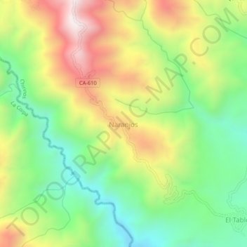
Name: Naranjos topographic map, elevation, terrain.
Location: Naranjos, Chirinos, San Ignacio, Cajamarca, Perú (-5.37103 -78.89820 -5.33103 -78.85820)
Average elevation: 1,109 m
Minimum elevation: 736 m
Maximum elevation: 1,618 m
Other topographic maps
Click on a map to view its topography, its elevation and its terrain.
Nueve De Octubre
Perú > Cajamarca > San Ignacio > Nueve De Octubre
Nueve De Octubre, San Ignacio, Provincia de San Ignacio, Cajamarca, Perú
Average elevation: 1,581 m