
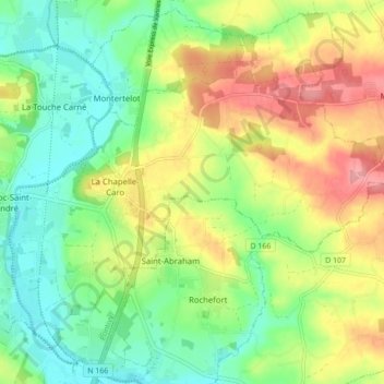
La Chapelle-Caro topographic map
Interactive map
Click on the map to display elevation.
About this map
Name: La Chapelle-Caro topographic map, elevation, terrain.
Average elevation: 56 m
Minimum elevation: 13 m
Maximum elevation: 119 m
Other topographic maps
Click on a map to view its topography, its elevation and its terrain.
Le Hingleuf
France > Bretagne > Morbihan > Val d'Oust
Le Hingleuf, La Chapelle-Caro, Val d'Oust, Pontivy, Morbihan, Bretagne, France métropolitaine, 56460, France
Average elevation: 47 m
Le Bout du Pont
France > Bretagne > Morbihan > Val d'Oust
Le Bout du Pont, La Chapelle-Caro, Val d'Oust, Pontivy, Morbihan, Bretagne, France métropolitaine, 56460, France
Average elevation: 47 m
Quily
France > Bretagne > Morbihan > Val d'Oust
Quily, Val d'Oust, Pontivy, Morbihan, Bretagne, France métropolitaine, 56460, France
Average elevation: 71 m
Le Roc-Saint-André
France > Bretagne > Morbihan > Val d'Oust
Le Roc-Saint-André, Val d'Oust, Pontivy, Morbihan, Bretagne, France métropolitaine, 56460, France
Average elevation: 50 m
La Vallée
France > Bretagne > Morbihan > Val d'Oust
La Vallée, La Chapelle-Caro, Val d'Oust, Pontivy, Morbihan, Bretagne, France métropolitaine, 56460, France
Average elevation: 46 m