Casas de Ves topographic map
Interactive map
Click on the map to display elevation.
About this map
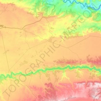
Name: Casas de Ves topographic map, elevation, terrain.
Location: Casas de Ves, Albacete, Castile-La Mancha, Spain (39.14504 -1.37030 39.33441 -1.21456)
Average elevation: 685 m
Minimum elevation: 367 m
Maximum elevation: 1,008 m
Other topographic maps
Click on a map to view its topography, its elevation and its terrain.
Villarrobledo
Villarrobledo is located in the center of La Mancha, a Spanish region with approximately 26.000 km2 of almost perfect plain, on the eastern half of the Submeseta Meridional with elevation between 600 and 800 meters above sea level, and bordered by the Montes de Toledo, Sierra Morena, Sierra de Alcaraz and…
Average elevation: 773 m
Cuenca
The climate of Cuenca is the typical hot-summer Mediterranean climate of Spain's "Meseta" (inner plateau). Winters are relatively cold, but summers are quite hot during the day with occasional cool nights. Spring and autumn seasons are short, with pleasant temperatures during the day but with rather cold…
Average elevation: 1,124 m
Santa Cruz de la Zarza
It is located in the northeast region of the province of Toledo, in the border between Toledo, Madrid and Cuenca far 85, 83 and 101 km of its provincial capitals respectively. Its length is 264.54 km2, and its altitude is 790 m. Bordered by the municipalities of Villamanrique de Tajo and Fuentidueña de Tajo…
Average elevation: 724 m
Ciudad Real
The province of Ciudad Real is located in central Spain and is the third largest province in the country with an area of 19,813 km2 (7,650 sq mi). To the north lies the Province of Toledo, to the northeast the Province of Cuenca, to the east the Province of Albacete, to the south lie the Provinces of Córdoba…
Average elevation: 683 m