
San Gregorio da Sassola topographic map
Interactive map
Click on the map to display elevation.
About this map
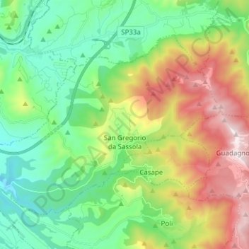
Name: San Gregorio da Sassola topographic map, elevation, terrain.
Location: San Gregorio da Sassola, Roma Capitale, Lazio, Italy (41.89058 12.79574 41.95780 12.92050)
Average elevation: 498 m
Minimum elevation: 137 m
Maximum elevation: 1,200 m
Other topographic maps
Click on a map to view its topography, its elevation and its terrain.
Rome
Italy > Lazio > Roma Capitale
Although the city centre is about 24 km (15 mi) inland from the Tyrrhenian Sea, the city territory extends to the shore, where the south-western district of Ostia is located. The altitude of the central part of Rome ranges from 13 m (43 ft) above sea level (at the base of the Pantheon) to 139 m (456 ft) above…
Average elevation: 78 m