
Make a donation
Gear up for your next adventure:
As an Amazon Associate, this site earns from qualifying purchases at no extra cost to you.
Ammerbach topographic map
Click on the map to display elevation.
Make a donation
Gear up for your next adventure:
As an Amazon Associate, this site earns from qualifying purchases at no extra cost to you.
About this map
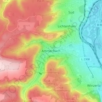
Name: Ammerbach topographic map, elevation, terrain.
Location: Ammerbach, Jena, Thuringia, Germany (50.89534 11.50422 50.91402 11.56811)
Average elevation: 272 m
Minimum elevation: 141 m
Maximum elevation: 417 m
Make a donation
Gear up for your next adventure:
As an Amazon Associate, this site earns from qualifying purchases at no extra cost to you.
Other topographic maps
Click on a map to view its topography, its elevation and its terrain.
Jena
Jena is situated in a hilly landscape in eastern Thuringia at the Saale river, between the Harz mountains 85 km (53 mi) in the north, the Thuringian Forest/Thuringian Highland 50 km (31 mi) in the southwest and the Ore Mountains, 75 km (47 mi) in the southeast. The municipal terrain is hilly with rugged slopes…
Average elevation: 289 m