
Turtuk topographic map
Interactive map
Click on the map to display elevation.
About this map
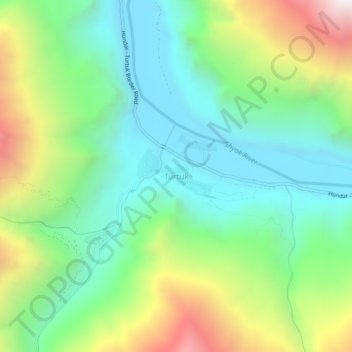
Name: Turtuk topographic map, elevation, terrain.
Location: Turtuk, Leh District, Ladakh, India (34.82470 76.80795 34.86470 76.84795)
Average elevation: 3,284 m
Minimum elevation: 2,776 m
Maximum elevation: 4,336 m
Other topographic maps
Click on a map to view its topography, its elevation and its terrain.
Kargil
India > Ladakh > Kargil Tehsil > Kargil
Kargil, Kargil Tehsil, Kargil District, Ladakh, 194103, India
Average elevation: 3,261 m
Leh
India > Ladakh > Leh Tehsil
Leh, Leh Tehsil, Leh district, Ladakh, India
Average elevation: 3,653 m