
Santiago topographic map
Interactive map
Click on the map to display elevation.
Santiago
The tallest summit is Pico de Antónia, elevation 1,392 m (4,567 ft), barely west of Picos, in the centre of the island. The second is Serra Malagueta between Assomada and Tarrafal in the north. Other mountain ranges include Órgãos in the municipality of São Lourenço dos Órgãos and Monte das Vacas near Praia.
About this map
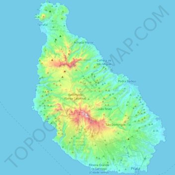
Name: Santiago topographic map, elevation, terrain.
Location: Santiago, Santa Catarina, Cape Verde (14.89985 -23.78162 15.34018 -23.42835)
Average elevation: 115 m
Minimum elevation: 0 m
Maximum elevation: 1,297 m
Other topographic maps
Click on a map to view its topography, its elevation and its terrain.