
Make a donation
Gear up for your next adventure:
As an Amazon Associate, this site earns from qualifying purchases at no extra cost to you.
Didwana topographic map
Click on the map to display elevation.
Make a donation
Gear up for your next adventure:
As an Amazon Associate, this site earns from qualifying purchases at no extra cost to you.
Didwana
Didwana is located at 27°24′N 74°34′E / 27.4°N 74.57°E / 27.4; 74.57. It has an average elevation of 336 metres (1102 feet). City divided in 40 Wards. It is an important station of Jodhpur-Delhi Broad gauge rail route of North West Railway Jodhpur division.
Make a donation
Gear up for your next adventure:
As an Amazon Associate, this site earns from qualifying purchases at no extra cost to you.
About this map
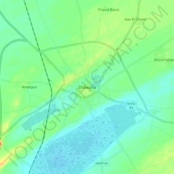
Name: Didwana topographic map, elevation, terrain.
Average elevation: 343 m
Minimum elevation: 330 m
Maximum elevation: 372 m
Make a donation
Gear up for your next adventure:
As an Amazon Associate, this site earns from qualifying purchases at no extra cost to you.