
Schrobenhausen topographic map
Interactive map
Click on the map to display elevation.
Schrobenhausen
Bodendenkmale und Bodenfunde aus Bronzezeit, Hallstattzeit und der keltischen Epoche lassen auf Nomadenstämme und Besiedelung durch Weidebauern schließen. Die gelegentlich behauptete Existenz eines römischen Kastells konnte bislang nicht nachgewiesen werden. Die nahegelegene Anhöhe „Maria Beinberg“, wo im 15./16. Jahrhundert eine Kapelle errichtet worden war, lässt aber vermuten, dass sich dort einst ein römisches Beobachtungskastell befunden haben muss. Die von dem „Berg“ aus einsehbare römische Straße Augsburg – Regensburg verlief ja durch die „Scharnitz“ zwischen Kühbach und Peutenhausen und weiter durch das heutige Stadtgebiet.
About this map
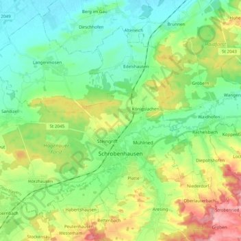
Name: Schrobenhausen topographic map, elevation, terrain.
Average elevation: 425 m
Minimum elevation: 379 m
Maximum elevation: 521 m
Other topographic maps
Click on a map to view its topography, its elevation and its terrain.