
Upham topographic map
Click on the map to display elevation.
About this map
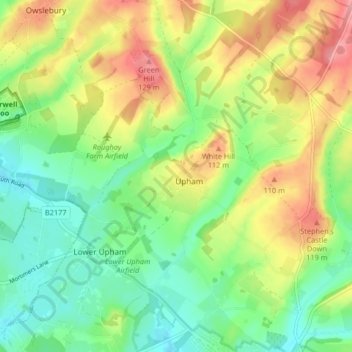
Name: Upham topographic map, elevation, terrain.
Location: Upham, Winchester, Hampshire, England, United Kingdom (50.95923 -1.26998 51.00822 -1.18775)
Average elevation: 74 m
Minimum elevation: 32 m
Maximum elevation: 135 m
Hampshire trails, hiking, mountain biking, running and outdoor activities
Other topographic maps
Click on a map to view its topography, its elevation and its terrain.
Headbourne Worthy
United Kingdom > England > Hampshire > Winchester > Kings Worthy
Average elevation: 66 m
Farley Chamberlayne
United Kingdom > England > Hampshire > Winchester > Hursley
Average elevation: 106 m
Dodsley Wood
United Kingdom > England > Hampshire > Winchester > East Stratton
Average elevation: 99 m
Store House Gully
United Kingdom > England > Hampshire > Winchester > Fisher's Pond
Average elevation: 45 m
Beacon Hill Nature Reserve
United Kingdom > England > Hampshire > Winchester > Exton
Average elevation: 128 m
Old Winchester Hill Iron Age Fort
United Kingdom > England > Hampshire > Winchester
Average elevation: 123 m
Brambridge
United Kingdom > England > Hampshire > Winchester > Colden Common > Brambridge
Average elevation: 37 m
Norton Lake
United Kingdom > England > Hampshire > Winchester > Sutton Scotney > Norton
Average elevation: 72 m