
Haldern topographic map
Interactive map
Click on the map to display elevation.
About this map
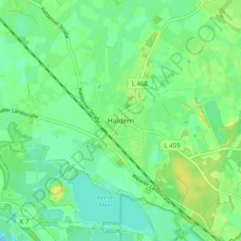
Name: Haldern topographic map, elevation, terrain.
Average elevation: 18 m
Minimum elevation: 10 m
Maximum elevation: 28 m
Other topographic maps
Click on a map to view its topography, its elevation and its terrain.
Lange Renne
Deutschland > Nordrhein-Westfalen > Kreis Kleve > Rees > Mehr
Lange Renne, Mehr, Rees, Kreis Kleve, Nordrhein-Westfalen, 46459, Deutschland
Average elevation: 19 m
Mehr
Deutschland > Nordrhein-Westfalen > Kreis Kleve > Rees
Mehr, Rees, Kreis Kleve, Nordrhein-Westfalen, 46459, Deutschland
Average elevation: 18 m