
Hovelange topographic map
Interactive map
Click on the map to display elevation.
About this map
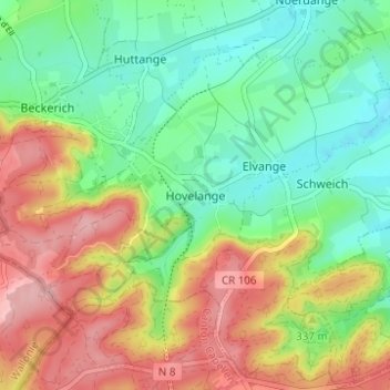
Name: Hovelange topographic map, elevation, terrain.
Location: Hovelange, Beckerich, Canton Redange, 8538, Luxembourg (49.70170 5.88653 49.74170 5.92653)
Average elevation: 325 m
Minimum elevation: 265 m
Maximum elevation: 409 m
Other topographic maps
Click on a map to view its topography, its elevation and its terrain.
Holtz
Holtz, Rambrouch, Canton Redange, 8820, Luxembourg
Average elevation: 443 m
Buschrodt
Buschrodt, Wahl, Canton Redange, 8610, Luxembourg
Average elevation: 384 m
Hostert
Hostert, Rambrouch, Canton Redange, 8537, Luxembourg
Average elevation: 420 m
Wolwelange
Wolwelange, Rambrouch, Canton Redange, 8833, Luxembourg
Average elevation: 452 m
Koetschette
Koetschette, Rambrouch, Canton Redange, 8821, Luxembourg
Average elevation: 478 m
Arsdorf
Arsdorf, Rambrouch, Canton Redange, 8809, Luxembourg
Average elevation: 447 m