
Sant'Angelo topographic map
Interactive map
Click on the map to display elevation.
About this map
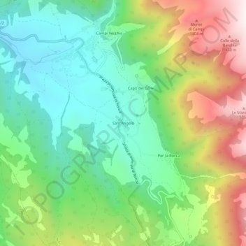
Name: Sant'Angelo topographic map, elevation, terrain.
Location: Sant'Angelo, Norcia, Perugia, Ombrie, 06046, Italie (42.81903 13.08363 42.85903 13.12363)
Average elevation: 987 m
Minimum elevation: 657 m
Maximum elevation: 1,573 m
Other topographic maps
Click on a map to view its topography, its elevation and its terrain.
Castelluccio
Italie > Ombrie > Perugia > Norcia
Castelluccio, Norcia, Perugia, Ombrie, 06046, Italie
Average elevation: 1,409 m