
Make a donation
Gear up for your next adventure:
As an Amazon Associate, this site earns from qualifying purchases at no extra cost to you.
Warscheneck topographic map
Click on the map to display elevation.
Make a donation
Gear up for your next adventure:
As an Amazon Associate, this site earns from qualifying purchases at no extra cost to you.
Warscheneck
Warscheneck leitet sich vom althochdeutschen Wort „wähse“ ab und bedeutet „scharf“. Toter Mann stammt vom keltischen „Tota magos“ ab. „Tota/Teuto“ bedeutet Volk und „magos“ Feld und verweist somit auf einen Versammlungsplatz. In Österreich und Deutschland gibt es mehrere gleichnamige Flurnamen. Stets sind es breite, flache Höhenkuppen mit weitem Rundblick, die von vielen Seiten relativ leicht erreicht werden können. Sie liegen etwas entfernt von den Ortschaften im freien Gelände.
Make a donation
Gear up for your next adventure:
As an Amazon Associate, this site earns from qualifying purchases at no extra cost to you.
About this map
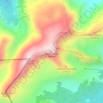
Name: Warscheneck topographic map, elevation, terrain.
Average elevation: 1,959 m
Minimum elevation: 1,603 m
Maximum elevation: 2,370 m
Make a donation
Gear up for your next adventure:
As an Amazon Associate, this site earns from qualifying purchases at no extra cost to you.