
Distrito Ciudad de Tunuyán topographic map
Interactive map
Click on the map to display elevation.
Distrito Ciudad de Tunuyán
Tunuyán is a city in the west of the province of Mendoza, Argentina, located on the western shore of the Tunuyán River, 80 km (50 mi) south from the provincial capital Mendoza and 100 km (62 mi) east of the Chilean border. It has 49,132 inhabitants, and is the head town of the Tunuyán Department. Along with the Tupungato Department and the San Carlos Department it makes up the "Valle de Uco" region, which is famous in the Argentine wine industry for its important and modern vineyards and wineries. Investments since the millennium, attracted by the climate, soil, and altitude combination, have transformed the area, making it one of Argentina's most important regions when it comes to high-quality wine production and its associated connoisseur-driven enotourism.
About this map
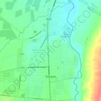
Name: Distrito Ciudad de Tunuyán topographic map, elevation, terrain.
Average elevation: 877 m
Minimum elevation: 854 m
Maximum elevation: 930 m
Other topographic maps
Click on a map to view its topography, its elevation and its terrain.
Cerro El Plata
Argentina > Mendoza > Distrito La Carrera
Cerro El Plata is the highest peak of the Cordón del Plata which is a subrange of the Andes. The mountain is located 65 kilometres (40 miles) southeast of Aconcagua and 60 kilometres (37 miles) west of the provincial capital, the city of Mendoza. Precipitation runoff from the mountains drains into the Mendoza…
Average elevation: 5,374 m
Andes
Argentina > Mendoza > Distrito Las Cuevas
The Andes Mountains are the highest mountain range outside Asia. The highest mountain outside Asia, Argentina's Mount Aconcagua, rises to an elevation of about 6,961 m (22,838 ft) above sea level. The peak of Chimborazo in the Ecuadorian Andes is farther from the Earth's center than any other location on the…
Average elevation: 6,208 m
Luján de Cuyo
Argentina > Mendoza > Departamento Luján de Cuyo > Luján de Cuyo
Average elevation: 951 m