
Boca do Risco topographic map
Interactive map
Click on the map to display elevation.
About this map
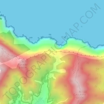
Name: Boca do Risco topographic map, elevation, terrain.
Location: Boca do Risco, Machico, Madeira, 9300-083, Portugal (32.75539 -16.77221 32.75549 -16.77211)
Average elevation: 226 m
Minimum elevation: -1 m
Maximum elevation: 625 m
Other topographic maps
Click on a map to view its topography, its elevation and its terrain.
Caniçal
Caniçal borders the municipal seat of Machico on its western frontier, and is surrounded by the Atlantic Ocean on the remaining borders. The roughly escarped terrain is prominent in the western border, where altitudes reach 800 metres above sea level and ravines are semi-active or dry year round. The…
Average elevation: 72 m
Porto da Cruz
The northern parish is enveloped by the mountains of Paul da Serra: Pico da Suna (1040 metres), Pico do Larano (765 metres) and Pico da Maiata (766 metres) are the highest points in the parish. Even along the coast, Penha de Águia (a mountainous escarpment 580 metres in altitude) is difficult to climb; the…
Average elevation: 448 m