
Make a donation
Gear up for your next adventure:
As an Amazon Associate, this site earns from qualifying purchases at no extra cost to you.
Boshruyeh County topographic map
Click on the map to display elevation.
Make a donation
Gear up for your next adventure:
As an Amazon Associate, this site earns from qualifying purchases at no extra cost to you.
About this map
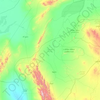
Name: Boshruyeh County topographic map, elevation, terrain.
Location: Boshruyeh County, South Khorasan Province, Iran (33.46215 57.00653 34.88547 57.95485)
Average elevation: 1,027 m
Minimum elevation: 620 m
Maximum elevation: 2,898 m
Make a donation
Gear up for your next adventure:
As an Amazon Associate, this site earns from qualifying purchases at no extra cost to you.
Other topographic maps
Click on a map to view its topography, its elevation and its terrain.
Iranian plateau
Iran > South Khorasan Province > Tabas County > دهستان دیهوک
The northwestern Iranian plateau, where the Pontic and Taurus Mountains converge, is rugged country with higher elevations, a more severe climate, and greater precipitation than are found on the Anatolian plateau. The region is known as the Anti-Taurus, and the average elevation of its peaks exceeds 3,000 m…
Average elevation: 1,061 m
Nehbandan
Iran > South Khorasan Province > Nehbandan County > دهستان نه
Nehbandan is located at an altitude of 1196 meters above sea level, and the heights of the north of this city reach 2500 meters above sea level. Nehbandan is located near the central desert of Iran. Precious stones in mines along with agriculture is another reason for the importance of Nehbandan. The people of…
Average elevation: 1,209 m
Make a donation
Gear up for your next adventure:
As an Amazon Associate, this site earns from qualifying purchases at no extra cost to you.
Sarbisheh
Iran > South Khorasan Province > Sarbisheh County > دهستان مؤمن آباد
Average elevation: 1,860 m
Make a donation
Gear up for your next adventure:
As an Amazon Associate, this site earns from qualifying purchases at no extra cost to you.
Kur Gaz-e Bala
Iran > South Khorasan Province > Birjand County > دهستان القورات
Average elevation: 1,861 m
Make a donation
Gear up for your next adventure:
As an Amazon Associate, this site earns from qualifying purchases at no extra cost to you.
Deh-e Shur
Iran > South Khorasan Province > Tabas County > دهشور > Deh-e Shur
Average elevation: 700 m
Make a donation
Gear up for your next adventure:
As an Amazon Associate, this site earns from qualifying purchases at no extra cost to you.
Abbasabad
Iran > South Khorasan Province > Birjand County > دهستان کاهشنگ > Qaleh Kuh > Abbasabad
Average elevation: 2,137 m