
Make a donation
Gear up for your next adventure:
As an Amazon Associate, this site earns from qualifying purchases at no extra cost to you.
Las Bellostas topographic map
Click on the map to display elevation.
Make a donation
Gear up for your next adventure:
As an Amazon Associate, this site earns from qualifying purchases at no extra cost to you.
Las Bellostas
Se sitúa a 17 km de Aínsa y a una altitud de 1.110 metros cerrando el valle del río Vero y entre éste y el río Balcés.
Make a donation
Gear up for your next adventure:
As an Amazon Associate, this site earns from qualifying purchases at no extra cost to you.
About this map
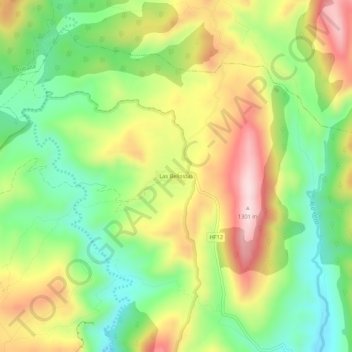
Name: Las Bellostas topographic map, elevation, terrain.
Location: Las Bellostas, Aínsa-Sobrarbe, Sobrarbe, Huesca, Aragón, España (42.33579 -0.02956 42.37579 0.01044)
Average elevation: 1,077 m
Minimum elevation: 912 m
Maximum elevation: 1,286 m
Make a donation
Gear up for your next adventure:
As an Amazon Associate, this site earns from qualifying purchases at no extra cost to you.
Other topographic maps
Click on a map to view its topography, its elevation and its terrain.
Make a donation
Gear up for your next adventure:
As an Amazon Associate, this site earns from qualifying purchases at no extra cost to you.